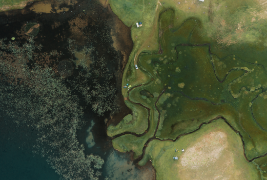
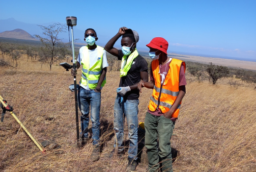
At HOPE, our team is our greatest asset. Comprising seasoned experts and visionaries, we are a multidisciplinary group united by a commitment to redefine conservation with precision, integrity, and measurable impact. Together, we bring a unique blend of academic excellence, practical expertise, and technological innovation to every project.
Our Measure and Model for Improved Agricultural Land Management IALM approach leverages advanced biogeochemical models to quantify GHG reductions and carbon sequestration from enhanced agricultural practices. It estimates fluxes linked to SOC changes, soil methanogenesis, and nitrogen fertilizer application, with periodic SOC measurements ensuring accuracy and robustness.
We utilize both active remote sensing, such as radar data from the Shuttle Radar Topography Mission (SRTM), and passive remote sensing, including imagery from Sentinel Planet NICFI, NASA Worldview, and ASTER satellites. Active remote sensing provides detailed topographic data, enabling us to analyze elevation, slope, and hydrology, which are critical for understanding landscape changes. Meanwhile, passive sensors like Sentinel-2 deliver multispectral data to monitor vegetation health, land cover changes, and seasonal dynamics.
Our bioacoustics technology captures the soundscapes of ecosystems, enabling the detection of species and biodiversity patterns at scale. By using artificial intelligence to analyze audio data, we can identify specific species based on their unique vocalizations, offering a cost-effective and non-invasive way to monitor ecosystem health.
The integration of eDNA allows us to detect species through traces of genetic material found in the environment, such as in soil, water, or organic matter like feces or skin cells. This method is particularly effective for identifying elusive or rare species and adds a powerful layer to our biodiversity datasets.
Thermal and motion-activated sensors are strategically deployed to capture high-resolution images and videos of wildlife. These sensors detect heat signatures and movements, providing real-time data on species behavior and habitat use without disrupting their natural environments.
The integration of eDNA allows us to detect species through traces of genetic material found in the environment, such as in soil, water, or organic matter like feces or skin cells. This method is particularly effective for identifying elusive or rare species and adds a powerful layer to our biodiversity datasets.
Ecological Niche Modeling is employed to predict species distribution based on environmental variables such as climate, soil type, vegetation, and topography. By combining these data, we create models that identify suitable habitats and potential corridors for species conservation, optimizing land management strategies.
The use of GPS (Global Positioning System) and GNSS (Global Navigation Satellite System) ensures precise georeferencing of in situ data collection points. These tools enable accurate tracking of environmental changes and the alignment of field observations with global datasets.
We actively involve local communities in data collection, leveraging their ecological knowledge and observations to complement our datasets. Through photographs, field notes, and direct engagement, we create a participatory approach that enhances both data quality and social inclusion.
Our cloud-based artificial intelligence systems process vast datasets from satellites, sensors, and field studies. These self-learning algorithms analyze patterns, detect anomalies, and provide data-driven insights into ecosystem health, ensuring that conservation actions are both timely and effective.